Farm infrastructure and Resource planning
Farm planning, is a process to allocate the scare resources of the farm to organize the farm production in such a way as to increase both the resource use efficiency as well as the income of the farmer.
A holistic approach to farm planning called Whole Farm Planning was developed in the mid-90’s, defining a farmers responsibility to give due consideration to ALL of the farm assets, (physical and non -physical) with the aim of optimizing it over an extended period of time (perhaps several generations); with respect to all of the aims which the farmer may aspire to, including profit, lifestyle, family wellbeing, sustainability of production, etc.
This process enables the farmer to achieve his objectives in regards to farm and family in a structured and organised manner. It also enables the farmer to carefully examine the resources and how best it can be utilized and provide the information required to make key decisions in relation to production. Lastly, it helps the farmer to identify input and credit needs in estimating future costs returns.
The plan is influenced by different enterprise possibilities based on natural resource data; by the availability, source and type of capital; as well as by the preference\experience of the farmer.
A comprehensive and integrated farm resource and infrastructure plan consists of three key components:
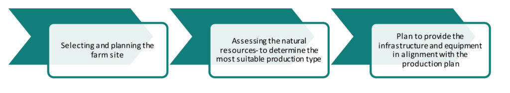
Selecting and planning the layout of the farm site should be done according to the activities that will be implemented, the structures and infrastructure required by these activities as well as the natural resources and natural landscape of the area. Careful site selection and planning is important to ensure that cost is kept at a minimum and that natural resources are optimized. For a feedlot or dairy the correct drainage should be planned to ensure that the runoff water can be controlled. Other factors to consider include
The table below summarises all factors to consider when planning the layout of the farm.
The most comprehensive assessment for farm planning is the assessment of the natural resources. This is best done either through the study of the maps and other documentation or by conducting a natural resource audit where the person collects the necessary data from the source. Four major factors would be of importance being (i) soil; (ii) water quality; (iii) climate; and (iv) vegetation.
As part of the planning process, soils need to be characterized and soil-maps prepared that indicate the difference in soil types across the farm. Land preparation techniques can then be selected with the aim of maintaining soil structure and avoiding soil erosion. As part of the characterization, the soil fertility status can also be determined and a fertilisation programme be developed.
Aspects of water quality that influence crop production include the concentration of specific ions and their ratios relative to each other.
The main climatic requirements for crops often form the basis of the decisions regarding area and cultivar to be planted. This decision will be based on a crop by crop basis and the requirements of individual crops need to be considered.
There are two types of vegetation which one should be concerned of in terms of agriculture: namely indigenous and invasive vegetation. Indigenous vegetation is defined as trees, under-storey plants, ground covered and plants occurring naturally in a specific area. Invasive vegetation is alien plants that have been brought into South Africa for their beauty, economic value, or for an ecological purpose. Invasive plants often do not have natural enemies and therefore tend to proliferate, thus competing with indigenous vegetation for food resources.
Having considered the entire resource offering, the farmer now will plan to provide the infrastructure and equipment in such a way that it complements the production process as well as ensures the sustainable use of the natural resources. Start the assessment and planning with capital intensive infrastructure components such as roads, irrigation/ water pipelines and buildings.
Then plan the production type infrastructure such as tractors, implements, combines, etc.
The table below summarises all aspects of importance to consider when conducting farm layout and resource planning:
| Factors to consider during layout planning | Factors to consider for natural resources planning | Factors to consider for infrastructure and equipment planning |
|---|---|---|
| Topography: Is it suitable (flats) for crop production and cattle grazing or (hilly) for tree plantations, orchards and vineyards? Draw a profile sketch indicating the highest and lowest point as well as the different slopes. Percentage level land is estimated. Determine the in- and outflow of water on the farm. Sufficient running water for cattle and sheep; what about a river for irrigation purposes? Location of the farm: How far is it from a market (fresh fruit and vegetables) or silo (maize, sunflower and wheat crops)? Accessible to labour: The availability of workers must also be taken into account as fresh fruit, vegetables, citrus and vines need more labourers (handpicking) than cattle farming. Access to the area: Is the farm accessible and will equipment required for production purposes be able to access the lands. Expected biomass to be removed from farm and required inputs to replace the loss. Positioning of infrastructure in relation to production activities and natural sources to minimize cost. Property borders: Identify all borders to confirm size of workable lands. Walk borders to determine where sensitive areas exist. For example, agricultural activity would be restricted in proximity to a stream or wetland that acts as a border or intersects a border. |
Soil analysis: • Appearance, nature, depth and thickness of layers • Presence of restricting layers in the upper 100cm • Presence of stones, gravel and concretions • Presence of internal drainage • Lateral movement of clay water and salts • Presence of symptoms of poor drainage • Soil Parent material • Potential Rooting depth • Compaction • StructureWater quality: • Total dissolved salts • Sodium adsorption ratio • Concentration of boron and chloride • Bicarbonate concentration in relation to calcium and magnesium.Climatic factors: • Temperature • Day length and light • Rainfall and humidity • Wind • Hail • Temperature.Naturally-occurring vegetation: including a demarcation between indigenous and invasive vegetation |
Access: Does the site have adequate entry and exit for all equipment in every season and time of day during which you will be farming? Fencing: Is the property adequately fenced? For livestock producers a permanent perimeter fence is generally necessary to keep livestock out of roads and other people’s properties. Telecommunications: this is not merely important for calls but also for data to access management information systems, GPS etc. Equipment storage: Identify and inspect locations for storing your equipment. Understand your limitations and any additional costs that may accrue. Machinery and implements: Identify the type of equipment required for production purposes. Is it available? What is the condition of this equipment. Housing: Identify all buildings that could be used as residences, or consider all areas that could be used for building sites or for siting mobile housing. Infrastructure: Make a list of all existing infrastructure, their condition, and estimated cost for repairs and additions, for both the immediate and long-term future of your business. Livestock facilities: Infrastructure may be required for housing or handling of livestock. Consider bio-security and isolation requirements, as well as the potential for herd or flock contamination. Inspect fencing and plan for the installation and maintenance of animal fencing and water systems. Electricity supply: The availability as well as price rates for power should be investigated. If it is determined that you will use a generator, identify and discuss proper storage facilities for the generator and its fuel source. Water infrastructure: Inspect and map the size and location as well as the condition of water infrastructure such as bore holes, pipelines, cribs etc. |